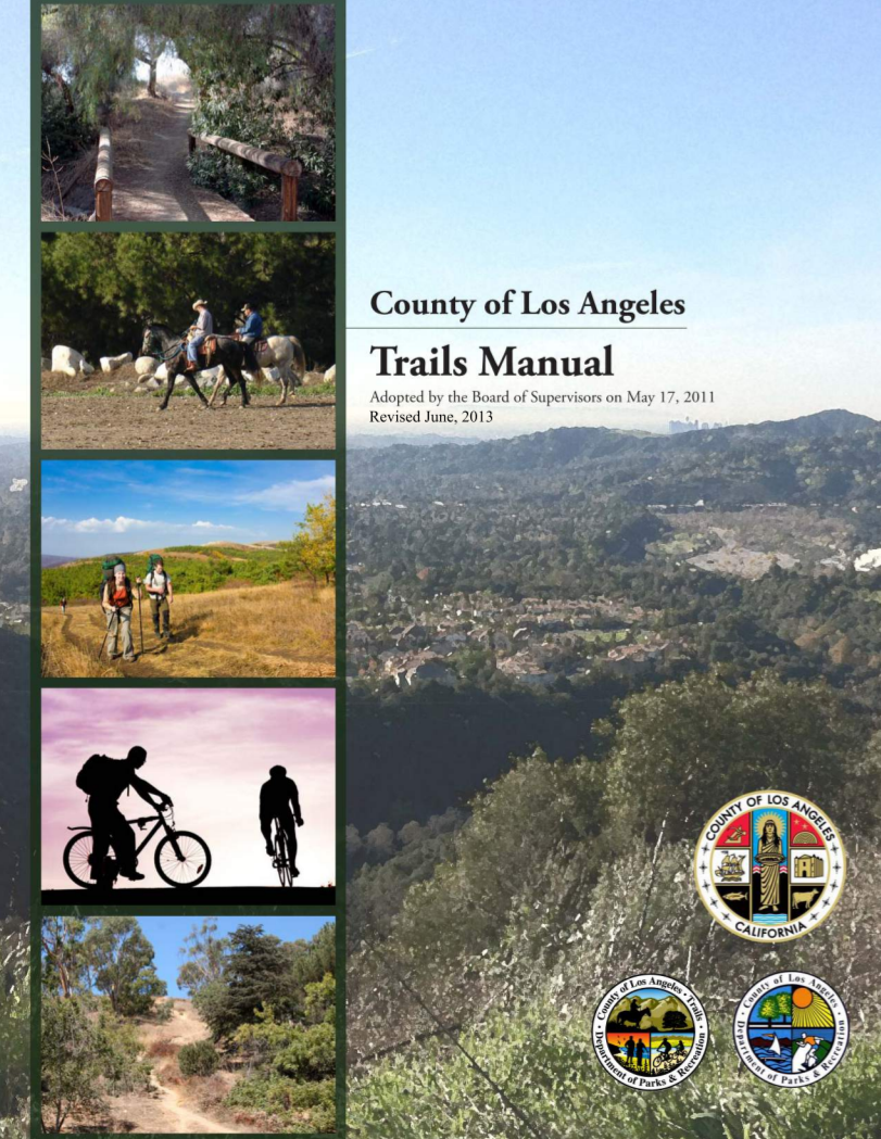
LETTER FROM THE DIRECTOR:
Thank you for your interest in the County of Los Angeles Trails Manual. The County of Los Angeles Department of Parks and Recreation (LACO-DPR) is honored to oversee the County of Los Angeles (County) parks and recreation system, which includes 63,000 acres of parks, lakes, trails, natural areas, and gardens. These recreational opportunities have been identified as essential to the quality of life among Americans. The availability of parks and recreational facilities is one of the most important factors in creating a high quality of life for residents in the County. Parks and recreational facilities create opportunities for people to access open space, natural resources, exercise, outdoor education, and new environments, promoting a connection with the environment, good health, and a sense of well being. The benefits and quality of experience that LACO-DPR trails provide for equestrians, hikers, and mountain bikers are unparalleled. The diverse landscape within the County provides Southern Californians and visitors with unique opportunities to enjoy desert, foothill, urban, and coastal trails that cannot be experienced in any other location. The Trails Manual provides the LACO-DPR staff, other County staff, and developers with guidelines and standards for trail planning, design, development, and maintenance of LACO-DPR trails. In consultation with numerous agencies, trails groups, and trail users, the Trails Manual is designed to continue the tradition of trails excellence in the County. The LACO-DPR is happy to present this Trails Manual to help guide and maintain the legacy of trail experiences that is unique to this County. The preparation of this Trails Manual is a result of a wide-reaching public participation effort, including private citizens and trails organizations throughout the County representing many user groups. The County over time will review and revise this manual as needed. As always, we welcome your input. Russ Guiney, Director, County of Los Angeles Department of Parks and Recreation
SECTION ES EXECUTIVE SUMMARY
The County of Los Angeles Trails Manual (Trails Manual) project was initiated in July 2010. Prior to the Trails Manual development, a County-wide trails manual had not been written or adopted. The County of Los Angeles Department of Parks and Recreation (LACO-DPR) manages the recreation system, including all soft (unpaved trails) with funding provided by the County of Los Angeles Board of Supervisors for planning, construction, operation, and maintenance of recreation facilities and programs in order to meet the diverse needs of the County of Los Angeles (County) residents and visitors. The purpose of the Trails Manual is to provide guidance to County departments, specifically LACO-DPR, that interface with trail planning, design, development, and maintenance of hiking, equestrian, and mountain biking recreational trails, while addressing physical and social constraints and opportunities associated with the diverse topographic and social conditions that occur in the unincorporated territory of the County. LACO-DPR will use the planning process delineated in the Trails Manual in considering the development of future trails. It is the policy of LACO-DPR that all trails in the County are multi-use (hiking, mountain biking, equestrian). The Trails Manual does not question the LACO-DPR multi-use policy. Rather, the Trails Manual accepts this policy and it is taken into consideration throughout the Trails Manual. The Trails Manual does not provide guidelines for safety, volunteer programs, education programs, and trail etiquette. The Trails Manual is intended as a procedural document. The Trails Manual is organized into seven sections and 13 appendices (A–M), which are referenced in the seven sections of the document: Section 1.0, Introduction. The Introduction discusses the purpose and need for the Trails Manual, how the Trails Manual will be applied, and how the Trails Manual was developed. Section 2.0, Trail Planning. Section 2.0 discusses the steps involved in planning a trail beginning with defining the goals and objectives for a project and including coordination with stakeholders, evaluation of recreational trail needs in the service area, and inventory of existing trails and recreational resources. This section describes how to create a conceptual trail alignment. Section 3.0, Environmental Compliance for Trails. Section 3.0 provides guidance to trail projects on complying with the National Environmental Policy Act (NEPA) as well as the California Environmental Quality Act (CEQA). This section contains a brief overview of the purposes of CEQA, the three-step CEQA process, descriptions of CEQA documents, and which regulatory agencies should be notified throughout the project. Section 4.0, Trail Design. Section 4.0 presents guidelines for the design of future County trails. A detailed description of trail mechanics, trail longevity, application of design guidelines, and constructability is provided. This section discusses the requirements for different trail environments: coastal, desert, urban, foothill, and flood control right-of-way. This section also addresses issues that arise with trails that are located within the jurisdictions of more than one agency, such as trail name and multi-use inconsistencies. Section 5.0, Trails Operation and Maintenance. Section 5.0 provides guidance on operating and maintaining trails. The guidelines are based on guidelines from established agencies and sources. A multi-year trail maintenance schedule and maintenance management system database is also discussed. Section 6.0, Report Authors. This section contains the list of persons involved in the development of the Trails Manual and special thanks. Section 7.0, References. This section contains the organizations and persons contacted or consulted during preparation of the document, a list of personnel involved in preparation of the environmental documentation, and a list of references. The list of references is annotated to identify the location of the cited reference material. Section 8.0, Index. The index is an alphabetized list of key terms used throughout the Trails Manual, with page numbers on which each key term is mentioned.
Section 1 | Introduction 1-9 SECTION 1.0 INTRODUCTION
The County of Los Angeles Department of Parks and Recreation (LACO-DPR) manages the recreation system with funding provided by the County of Los Angeles Board of Supervisors for planning, construction, operation, and maintenance of recreation facilities and programs. LACO-DPR is responsible for providing parks and recreational facilities to meet the diverse needs of the County of Los Angeles (County) residents and visitors. Maintenance of existing trails and development of additional high-quality trails is one of the most cost-effective means of addressing the deficiency of recreational facilities identified in the County of Los Angeles Inventory of Parks Facilities and Areas of Jurisdiction and the Strategic Asset Management Plan (SAMP) for 2020.1,2 Trails offer multiple recreational opportunities to County residents and visitors, providing access to open space and related natural resources, and facilitating exercise, outdoor education, and opportunities to explore new environments. These assets are essential components of the quality of life valued by Southern Californians. The ability to provide these benefits within the County requires maintenance of existing trails and planning, design, development, and maintenance of new trails. The need and usefulness of encouraging healthy communities through the provision of recreational facilities has been exemplified by the “Healthy Parks” program coordinated by LACO-DPR, whose goal is to “improve the quality of life for all Los Angeles County residents” by “creating healthy communities through people, parks and programs.”
1.1 COUNTY STRATEGIC PLAN FOR 2010 GOALS, OBJECTIVES, AND POLICIES
A Parks and Recreation Strategic Plan for 2010 describes a goal, related objective, and policy to guide trail planning and development:4 1 County of Los Angeles Department of Parks and Recreation. 2003. County of Los Angeles Inventory of Park Facilities and Areas of Jurisdiction. Contact: Department of Regional Planning, Hall of Records, 320 West Temple Street, Los Angeles, CA 90012. 2 County of Los Angeles Department of Parks and Recreation. April 2004. Strategic Asset Management Plan (SAMP) for 2020. Prepared by: County of Los Angeles Chief Executive Office and County of Los Angeles Department of Parks and Recreation, with technical assistance by Sapphos Environmental, Inc. 3 County of Los Angeles Department of Parks and Recreation. 6 December 2005. “Healthy Parks.” Web site. Available at: http://parks.co.la. ca.us/HealthyParks.htm 4 County of Los Angeles Department of Parks and Recreation. May 1992. A Parks and Recreation Strategic Plan for 2010. Contact: 433 South Vermont Avenue, 4th Floor, Los Angeles, CA 90020. Goal: Provide a system-wide level of planning processes for both longand short-term solutions. Objective: Provide a system of park and recreation facilities that meet the diversified needs of residents. Policy: Provide a system of multi-use (equestrian, hiking, and mountain biking) trails for a diverse group of public users throughout the County that connect local, state, and federal trail systems and link recreational areas to residential, commercial, institutional, and industrial areas.
1.2 PURPOSE AND NEED
Purpose The purpose of this Trails Manual is to provide an accessible resource that can be used for trail planning, design, construction, and maintenance within the County of Los Angeles. This manual provides guidance to County departments that interface with trail planning, design, development, and maintenance of all trails subject to the discretionary land use authority of the County of Los Angeles. Specifically, these departments include the Department of Regional Planning, the Department of Public Works, and the Department of Parks and Recreation. This Trails Manual recognizes the existence of a broader regional trail network that exists in the County of Los Angeles and surrounding counties that provides access to recreational resources operated by federal, state, and local agencies. Thus, this Trails Manual provides guidelines for implementation of the goals, objectives, and purpose for the 2010 Strategic Plan related to trails.5 Specifically, the manual provides sources of information and physical factors to be considered when analyzing the regional planning context, design, and development of trails that create the highest quality recreational experience and the capacity to serve the diverse recreational needs of County residents and visitors, while undertaking the necessary outreach with community and regulatory stakeholders. 5 County of Los Angeles Department of Parks and Recreation. May 1992. A Parks and Recreation Strategic Plan for 2010. Contact: 433 South Vermont Avenue, 4th Floor, Los Angeles, CA 90020. 1-10 Section 1 | Introduction Section 1 | Introduction 1-11 conditions. Consistent with the overarching goal of the County and the LACO-DPR to increase the number of trails available to users, the environment, topography, and many other factors may necessitate a deviation from the recommendations and guidelines contained in this Trails Manual.
The guidelines provided in this Trails Manual are intended to be used by County departments engaged in the planning, design, construction, and maintenance of hiking, equestrian, and mountain biking recreational trails within the County of Los Angeles. The Trails Manual sets the guidelines for reviewing plans and specifications for trails that are provided in conjunction with land use planning and the entitlement process for projects proposed for development within the County. Proposed developments will be reviewed for consistency with the Trails Manual. Proposed private development that includes a County trail would only be able to supersede the Trails Manual guidelines in its design and layout upon specific approval of the Board of Supervisors. This manual was developed as a management and field tool for design, construction, operation, and maintenance of trails in the County of Los Angeles. It provides guidelines for both 6 County of Los Angeles Department of Parks and Recreation. April 2004. Strategic Asset Management Plan (SAMP) for 2020. Prepared by: County of Los Angeles Chief Executive Office and County of Los Angeles Department of Parks and Recreation, with technical assistance by Sapphos Environmental, Inc. supervisors and lead personnel responsible for trail design, construction, and maintenance activities. It also provides the County with a checklist of key factors that shall be considered in the estimation of costs for trail construction and maintenance programs. The establishment of well-defined trail types, guidelines, and priorities facilitates the provision of consistent, high-quality trail experiences to residents of and visitors to the County of Los Angeles. The Trails Manual sets guidelines for all trails under the jurisdiction of the LACO-DPR. Trails within the jurisdiction of the LACO-DPR include unpaved trails, also known as soft trails; however, small portions of such trails may be paved (pavement can extend up to approximately 100 feet on a soft trail). Fully paved trails, also known as hard trails, are under the jurisdiction of the County of Los Angeles Department of Public Works (LACO-DPW). The framework for planning, design, entitlement, construction, operation, and maintenance of trails will affect the network of trails within the County of Los Angeles, including unincorporated territories of the County. The framework is to provide County residents and visitors with an enjoyable recreational experience consistent with the provisions of the County of Los Angeles General Plan. The geographic scope of the Trails Manual is limited to the unincorporated territory of the County of Los Angeles, while the incorporated cities in the County of Los Angeles have the purview to establish policies and guidelines that meet the needs of their respective jurisdictions. The Trails Manual is not retroactive to existing trails. The Trails Manual recognizes the entire Los Angeles County as a whole and not just a specific area or city. The Trails Manual is intended to provide guidelines for the diverse topography and environmental conditions that occur throughout the County of Los Angeles. The Trails Manual was specifically designed to be able to be adopted by cities who share the County’s multi-use trail planning policy. This manual does not intend to supplant, nor is it capable of supplanting, trained, experienced, and skilled trail supervisors and workers. For experienced personnel, the manual is intended only to supplement knowledge and provide a resource for operational guidance. However, the manual can provide a base knowledge of trail design, construction, and management practices for the inexperienced manager or supervisor. This manual does not create any binding legal or procedural requirements regarding trail planning, design, construction, or implementation, nor does it limit the discretion of the County of Los Angeles to deviate from the recommendations and guidelines contained in this Trails Manual based on specific situations or unique site 1-12 Section 1 | Introduction 1.5
RELATIONSHIP OF THE TRAILS MANUAL TO THE STRATEGIC ASSET MANAGEMENT PLAN FOR 2020
The SAMP18 provides a strategic plan for development of recreational facilities and programs to serve the diverse needs of County residents and visitors through 2020, in light of existing deficiencies and anticipated population growth and recreation trends. The population of California is expected to grow to 45.4 million in 2020, leading the nation in job, population, and income growth.19 Similarly, the incorporated and unincorporated population of the County is projected to grow to 11.6 million in 2020.20 According to the SAMP, population growth, demographic shifts, and cultural variances cause changes in the need for passive and active recreational activities and programs to serve both the existing and future residents of the County.21 The SAMP provides a tool for the prioritization of County resources for refurbishment of existing recreational facilities and the development of new facilities to meet the public demand and accommodate recreational programs over a planning horizon of 20 years. The data presented in the SAMP demonstrate that trail-based recreational activities, including hiking, horseback riding, and mountain biking, are expected to continue to increase in popularity, thus accelerating the wear and tear of existing trail facilities and exacerbating the existing Countywide deficiency for trails. In an effort to support advanced planning activities related to trails, the National Recreation and Park Association goal of providing 1 mile of trail per 1,000 people (approximately 50 feet of trail per person) and the assumed rate of 11 percent of the population engaged in the use of trails were used to anticipate existing and future demand for trails. As a reference, the County of San Diego utilizes a baseline level of service of 0.8 mile of trail per 1,000 residents.22 18 County of Los Angeles Department of Parks and Recreation. April 2004. Strategic Asset Management Plan (SAMP) for 2020. Prepared by: County of Los Angeles Chief Executive Office and County of Los Angeles Department of Parks and Recreation, with technical assistance by Sapphos Environmental, Inc. 19 U.S. Census Bureau. Last updated 15 July 2003. State and County QuickFacts, Los Angeles County, California. Web site. Available at: http://quickfacts.census.gov/qfd/states/06/06037.html 20 U.S. Census Bureau. Last updated 15 July 2003. State and County QuickFacts, Los Angeles County, California. Web site. Available at: http://quickfacts.census.gov/qfd/states/06/06037.html 21 County of Los Angeles Department of Parks and Recreation. April 2004. Strategic Asset Management Plan (SAMP) for 2020. Prepared by: County of Los Angeles Chief Executive Office and County of Los Angeles Department of Parks and Recreation, with technical assistance by Sapphos Environmental, Inc. 22 San Diego County. 2005. County Trails Program and the Community Trails Master Plan. Contact: San Diego County Department of Parks and Recreation, Resource Management Division, 5201 Ruffin Road, Suite P, San Diego, CA.
1.4 TRAILS MANUAL DEVELOPMENT
The Trails Manual is an independent document and project, which references other County and Department documents for clarity. Preparation of the Trails Manual project was initiated in July 2010. The guidelines provided in this Trails Manual are based on an extensive literature review of trail design standards and specifications; outreach to trail planning, design, and maintenance professionals at federal, state, county, and local agencies; outreach to community-based trail advocacy groups, including the Altadena Crest Trail Restoration Working Group (ACTRWG) and the La Cañada Flintridge Trails Council; site-specific investigations of existing County trails and other trails located within the County; and consulting input from a variety of technical specialists, including landscape and trail planners and designers, environmental analysts, biologists, cultural resource specialists, geologists, and trail construction specialists. Numerous trail guidelines were evaluated, including U.S. Department of Agriculture Forest Service specifications and the Trail Construction and Maintenance Notebook,7,8 California State Parks Trails Handbook,9 Santa Monica Mountains Area Recreation Trails Coordination Project Final Summary Report,10 San Diego County Trails Program,11 and general trail design publications such as Natural Surface Trails by Design; 12 International Mountain Bicycling Association’s 7 U.S. Department of Agriculture Forest Service. September 1996. Standard Specifications for Construction and Maintenance of Trails, EM-7720- 103. Contact: Forest Service, Engineering Staff, Washington, DC. 8 U.S. Department of Agriculture Forest Service. April 2004. Trail Construction and Maintenance Notebook. Contact: Forest Service Missoula Technology and Development Center, 5785 Hwy, 10 West, Missoula, MT. 9 California State Parks. 1998. Trails Handbook. Contact: California State Parks, Statewide Trails Office, P.O. Box 942896, Sacramento, CA. 10 Santa Monica Mountains Area Recreation Trails Coordination Project. September 1997. Final Summary Report. Contact: SMMART Coordination Project, c/o Rivers, Trails and Conservation Assistance Program, National Park Service, 600 Harrison Street, Suite 600, San Francisco, CA 94107. Available at: http://www.nps.gov/samo/parkmgmt/ smmartreportsept1997.htm 11 San Diego County. 2005. County Trails Program and the Community Trails Master Plan. Contact: San Diego County Department of Parks and Recreation, Resource Management Division, 5201 Ruffin Road, Suite P, San Diego, CA. 12 Parker, Troy Scott. 2004. Natural Surface Trails by Design. Boulder, CO: Natureshape LLC. (IMBA) Trail Solutions; 13 Trails for the Twenty-First Century: Planning, Design, and Management Manual for Multi-Use Trails; 14 U.S. Forest Service’s Equestrian Design Guidebook for Trails, Trailheads and Campgrounds;15 and the Equestrian Trails, Inc.’s Trails Manual.16 The notice for the access to the Draft Trails Manual on the Trails Manual Web site and information on the six public meetings with at least one in each of the Supervisorial Districts was sent via e-mail to over five hundred (500) e-mail addresses, including all interested parties that participated in the scoping meetings for Trails Manual in fall of 2010. Approximately seventy-five (75) members of the public attended the six public meetings for the Draft Trails Manual in each of the Supervisorial Districts. The six public meetings in each of the Supervisorial Districts ended when all of the members of the public in attendance had provided all of their comments. Approximately three hundred (300) comments were received from the public meetings; via e-mail, Web site submissions, and letters; and from other agencies. The County has determined that the Trails Manual is a ministerial project, consistent with the provision of Section 15268 of the State California Environmental Quality Act (CEQA) Guidelines and is exempt from CEQA. However, Section 3, Environmental Compliance for Trails, discloses that construction of a trail constitutes a “project” and is subject to the procedural provisions of CEQA. Future updates of the Trails Manual are not anticipated on an annual basis, but will be conducted on an as-needed basis, at the discretion of the Director of the LACO-DPR or the Director’s designee. The County would review the proposed updates to determine if they could potentially result in any environmental issues. If so, the project would undergo CEQA review, and if CEQA analysis is required, all required public scoping, noticing, and public review requirements would be undertaken. Environmental issues are defined in the State CEQA Guidelines.17 13 International Mountain Bicycling Association. 2004. Trail Solutions. Boulder, CO: International Mountain Bicycling Association. 14 Flink, Charles A., Kristine Olka, and Robert M. Searns. 2001. Trails for the Twenty-First Century: Planning, Design, and Management Manual for Multi-Use Trails. Washington, DC: Island Press. 15 Hancock, Jan, Kim Jones Vander Hoek, Sunni Bradshaw, James D. Coffman, and Jeffrey Engelman. U.S. Department of Agriculture Forest Service, Technology and Development Program. 2007 [Reprinted 2009]. Equestrian Design Guidebook for Trails, Trailheads, and Campgrounds. Missoula, MT. 16 Vogel, Charles. Equestrian Trails, Inc. 1982. Trails Manual. Sylmar, CA: Equestrian Trails, Inc. 17 California Code of Regulations. Title 14, Division 6, Chapter 3, Sections 15000–15387, Appendix G. Trails are an integral part of the American and Southern California lifestyle. The Southern California climate allows County residents and visitors to enjoy trails throughout the year. Many of the County’s trails were developed in the 1930s and continue to be in use today (Appendix A, History of Trail Development). This Trails Manual provides a framework for preserving and continuing this rich legacy of trail development and recreational trail uses. Need The County of Los Angeles has many miles of existing (formal) and historic trails (informal) and roads for recreational use. Given current population trends, the County needs to build more than 1,000 miles of trails to meet the anticipated demand for trails by 2020. This Trails Manual establishes the necessary planning, design, construction, and maintenance guidelines to ensure the quality of the recreational experience provided by existing and proposed County trails.6 This Trails Manual provides a process to ensure quality planning and design that recognizes the opportunities and constraints represented by the physical environment; provides construction guidelines to ensure proper drainage and minimize erosion; and specifies maintenance procedures to ensure that trails are accessible, safe, and aesthetically pleasing.
Section 2 | Trail Planning 2-1 SECTION 2.0 TRAIL PLANNING
Consideration of regional context, project objectives, and the constraints and opportunities that each site presents is essential to the planning and construction of high-quality trails that will provide for the diverse needs of County of Los Angeles (County) residents and visitors. The trail planning process generally includes research and data gathering for the site, public outreach to stakeholders, and site-specific analysis and investigation of integration of and/interconnectivity of regional trail systems throughout Southern California. The results of the trail planning process will serve as the basis for a feasibility analysis of possible trail alignments that incorporate the goals and objectives of the project. Other factors that can be determined through the trail planning process and subsequent feasibility analysis are the anticipated cost for construction, operation, and maintenance of trails based on the physical characteristics of the site and the anticipated capacity of the trail. Recreation trends, as well as supply and demand data, can be used as the basis for analyzing the recreation planning objectives within a park planning area, a community plan, a specific plan, a master-planned community, or a project. Frequently, the trail planning process involves repeated refinement of trail segment options as new data are obtained and stakeholders are consulted. The quality of the final project will be directly related to the quality of the input provided during the project planning process (Figure 2-1, Trail Planning Flowchart). There are numerous useful trail construction and maintenance books, trail guidebooks, agencies that plan and direct trail projects, and suppliers of trail products that are useful during the trail planning process (Appendix B, Trail Resources). It is the policy of the County of Los Angeles Department of Parks and Recreation (LACO-DPR) to accommodate multiuse trails (hiking, mountain biking, equestrian). Section 2 of the Trails Manual provides guidance for assessing the feasibility of accommodating multi-use as an element of the trail planning process. The Trails Manual acknowledges that it is not feasible, in all instances to accommodate all three uses on every trail. In addition, occasions arise where trails will not be open to multiple uses due to site-specific environmental constraints, which may necessitate limitations of a particular type of use.
2.1 STEP 1: DEFINE PROJECT GOALS AND OBJECTIVES
The first step in the trail planning process is to define the project goals and objectives that will guide the planning and design process. The LACO-DPR staff and developers will determine the goals and objectives of each trail or trail segment. There are several potential scenarios that result in the development of trails within the unincorporated territory of the County. Where public funds are used to support the development of new trails, the County serves as the project proponent. In some instances, another federal, state, or local public agency may request an easement over lands administered by the County, and in that instance the public agency would be the project proponent. In some instances, a private entity may seek an easement across lands administered by the County, and in that instance the private entity would be the project proponent. Finally, when a party is seeking a discretionary land use entitlement from the County of Los Angeles, the approval of which is conditioned on providing a trail easement or construction, operation, and/ or maintenance of a trail, the party seeking the entitlement is referred to as the developer. These goals and objectives may have to be updated as the project progresses and new data are obtained and stakeholders are consulted.
2.1.1 Goal Statement
The goal statement is usually linked to an identified community need or in conjunction with a proposed development project. It is a statement of what the project is attempting to achieve. The goal statement for a trail project is linked to the type of need, as well as the geographic area where the need was identified.
2.1.2 Project Objectives
The project objectives define standards that must be achieved for the project goals to be met. Project objectives are frequently linked to planning policies related to the level or quality of service that is intended to be provided to County residents and visitors. Whenever possible, the objectives should be tied into statutes, laws, and regulations; goals or polices of the adopted general plan; other relevant planning guidelines; and industry standards. The stakeholder participation process is complex and affects all facets of project planning, entitlement, construction, operation, and maintenance. Appendix C, Stakeholder Coordination, provides additional information.
APPENDIX A
HISTORY OF TRAIL DEVELOPMENT
The history of trails in the western United States is primarily an account of trails in the backcountry, far away from cities and
towns. Until the last century, the majority of country trail users expected to be on the trail for long periods of time. They were
miners, ranchers, foresters, and trappers, and they came well prepared with ample provisions carried by pack animals. Because
distances were far, and loads were heavy, most of the trails were built at low to moderate grades—grades preferred by horses,
donkeys, and mules. The geography of the rugged western peaks lent themselves to gently climbing trails, which ran along the
contour of the slopes, nearly perpendicular to the fall-line. An added advantage to this way of building trails was that, because they
were more resistant to erosion, the trails required less maintenance—a service that was hard to provide in the backcountry. In the late 1800s and early 1900s, as the local trading posts, mining towns, and harbor cities grew, “city folk” sought ways to
enjoy the solitude and beauty of nature, and recreational trails became popular. These trails were built to the same standard as
the working trails, as noted in an entry from the crew foreman’s report of the 1915 construction accomplished on the John Muir
Trail in the Sierra National Forest. Tread, 30 inches minimum width. Plenty of turnouts provided in dangerous places. Grade in no case except under extraordinary conditions exceeding 15 percent. The exceptions so far as noted were extremely few.
Carrying on this tradition, in the 1930s, local trails were built or improved through federal Works Progress Administration (WPA)
programs. Examples of this work can be seen scattered throughout the foothills along creek beds, trails, and in campgrounds.
Natural rock from the area was used to build walls, stairs, and small dams. Many of the trails built through the WPA programs
still exist in good condition today and require minimal maintenance. Good examples of WPA work can be found in the foothills
north of the Los Angeles Basin. The County of Los Angeles (County) covers more than 4,000 acres of area that cover vast topographic differences, including numerous climatic regions from coastlines, alpine mountain regions, and deserts. The County provides residents and visitors with access to numerous outstanding and unique recreational resources from the Angeles National Forest to the Santa Monica
Mountains National Recreation Area (Figure A-1, Santa Monica Mountains National Recreation Area; Figure A-2, Angeles National
Forest). Also within the County are a combination of 18 state parks, state recreational areas, and state historical parks. The ability
for individuals to access the multiple recreational assets within the County can be greatly enhanced through the development of
trail standards and plans to develop new and connecting trails. The County of Los Angeles has many miles of existing (formal)
and historic trails (informal) and roads for recreational use. (Figure A-3, Los Angeles County Existing and Proposed Regional Trail
Network). Since the 1950s, trails within the County have become a very valued resource as has the conservation of open space. One of the
largest County recreational trail assets is the 22-mile LARIO trail system, which was developed along the flood control channels
of the Los Angeles River and Rio Hondo Channel, and which provides a major regional trail with access to seven parks adjacent
to the Los Angeles River and Rio Hondo Channels. The LARIO trail is maintained by the County Department of Public Works
and Department of Parks and Recreation. To assist the public in using the County trail system, the Riding and Hiking Trails of Los Angeles County map was published in 1992 and was included in the Parks and Recreation Strategic Plan for 2010.
The Riding and Hiking Trails of Los Angeles County was updated in 2001 and provides the name and locations of major trails within the County, including those operated by the County, various other agencies, and the forest service. The conservation of open space within the County has been enhanced with the initiation of the Santa Monica Mountains National Recreation Area and the Santa Monica Mountains Conservancy. The Santa Monica Mountains National Recreation Area, the world’s largest urban national park, was designated on November 10, 1978. More than 70 government agencies, including the County of Los Angeles, in collaboration with private landowners work together to provide places for people to live, work, and recreate while protecting the natural and cultural resources in the mountains and on the seashore. This cooperative effort has initiated the construction of the Backbone Trail, a 65-mile-long trail intended to unite the patchwork of public parklands. The Santa Monica Mountains Conservancy was established in 1980 by the California State Legislature. The mission
of the conservancy is to work together with citizens; community-based organizations; federal, state, and local government; and
other park agencies to buy back, preserve, protect, restore, and enhance land in Southern California in order to form a publicly
accessible interlinking system of urban, rural and river parks, open space, trails, and wildlife habitats.
Another significant trail plan within the County was the Rim of the Valley Trail Corridor Master Plan, which provided a plan for
the development of a trail system by the Santa Monica Mountains Conservancy around the San Fernando/La Crescenta Valleys.
This trail, which is to be known as the Rim of the Valley Trail will encircle the San Fernando and La Crescenta Valleys unifying
various parts of the corridors recreational system. The County has continued to pursue additional trail planning and the provision of recreational trails through the development of the Antelope Valley Backbone Trail System and the Santa Clarita Backbone Trail System. These systems, finalized in 2006, were developed to ensure future trails are developed in a connected manner throughout the Antelope and Santa Clarita Valleys. The Recreational Trails Plan produced by the California State Parks is developed to provide guidance for establishing and maintaining California’s trail systems, including integrating with local agencies trail systems.9
The first California Recreational Trails Plan was produced in 1978. The 1978 California Recreational Trails Plan directed the creation of trail corridors and provided a general guide for the future growth of California’s trail system. The California Recreational Trails Plan was updated
in 2001 and provides trail goals for the state in terms of funding, inventorying, planning, and encouraging use of the trails from
multiple users. In addition, the plan includes the 2000 California Trail Corridors (Figure A-4, California Trail Corridors), which
updates the 1978 Hiking and Equestrian Trails in California. The updated map includes nine trail corridors in the County,
including the Pacific Coast, the Pacific Crest, the Backbone Trail, the Rim of the Valley, the LARIO, the San Gabriel River, the
Santa Clara River, the Whittier-Ortega Corridor, and the Juan Bautista de Anza National Historic Trail.
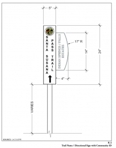
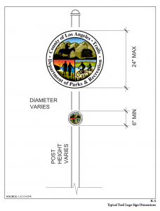
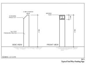
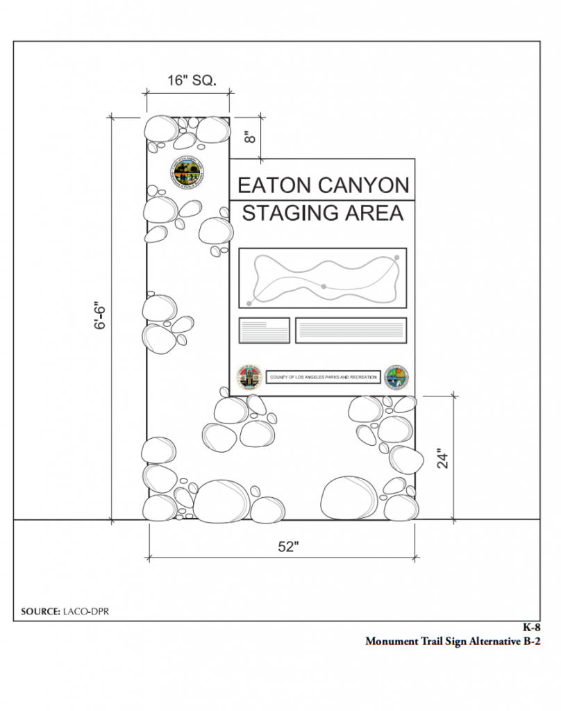
APPENDIX K WAY-FINDING SIGNS LACO-DPR WAY-FINDING SIGN PROGRAMThe County of Los Angeles Department of Parks and Recreation (LACO-DPR) has adopted a trail way-finding sign program. Description and Purpose: The intent of this primary trail way-finding sign program is to identify the typical County trail signs, which would be applied Countywide, cognizant of limited staff and funding resources. The trails logo was approved in 2010 by the LACO-DPR Director and has been applied in trail staging areas in a few locations. The goal is to apply this program for “branding” purposes. The trail monumental signs include two styles, one reflecting a contemporary design and another more rustic version for application in either wilderness or rural settings depending on the surrounding contexts. The way-finding sign is new to the LACO-DPR; while being simplistic, it is intended to be easy to maintain and readable. Graphic Example: Figure K-1, Typical Trail Sign Combinations; Figure K-2, Trail Name / Directional Sign with Community ID; Figure K-3, Typical Regulatory Sign; Figure K-4, Typical Trail Logo Sign Dimensions; Figure K-5, Typical Trail WayFinding Sign; Figure K-6, Typical Trail Way-Finding Sign Mileage Marker; Figure K-7, Monument Trail Sign Alternative A-1; and Figure K-8, Monument Trail Sign Alternative B-2 HIGHWAY SIGNS Highway signs are regulated by various agencies (e.g., state, county, municipalities) and should conform to relevant agency standards. Information Signs Description and Purpose: Information signs provide basic trail information to motorists and trail users at the initial highway approach to the trailhead, public recreation area, and places of cultural interest. Approaching motorists should be able to read the sign from the roadway and well in advance of the highway exit ramp. Sample Way-finding Sign Text: “County of Los Angeles Wonderland Trail—1,000 feet” (in some applications, signs may include a County trails logo) Location and Frequency: Posting of signs falls under the jurisdiction of the relevant highway regulatory agency, such as the California Department of Transportation (Caltrans) or U.S. Department of Transportation. All highway signs should be coordinated with the appropriate highway agency. Size and Color: The size and color of signs fall under the jurisdiction of the relevant highway regulatory agency such as Caltrans or U.S. Department of Transportation, and all highway signs should be coordinated with the appropriate highway agency. Highway information signs, such as brown recreation signs, direct motorists and trail users to areas of public recreation and cultural interest. Signs should follow the U.S. Department of Transportation, Federal Highway Administration Manual on Uniform Traffic Control Devices (MUTCD): Standard Highway Signs. 1 Other Considerations: Signs may be subtle if calling attention to the trail is not desirable (e.g., parking problems). Graphic Example: Figure K-9, Sample Highway Sign; Figure K-10, Standard MUTCD Sign; Figure K-11, Sample Trail Marker; and Figure K-12, Sample Trail Marker.


Warning Signs Description and Purpose:
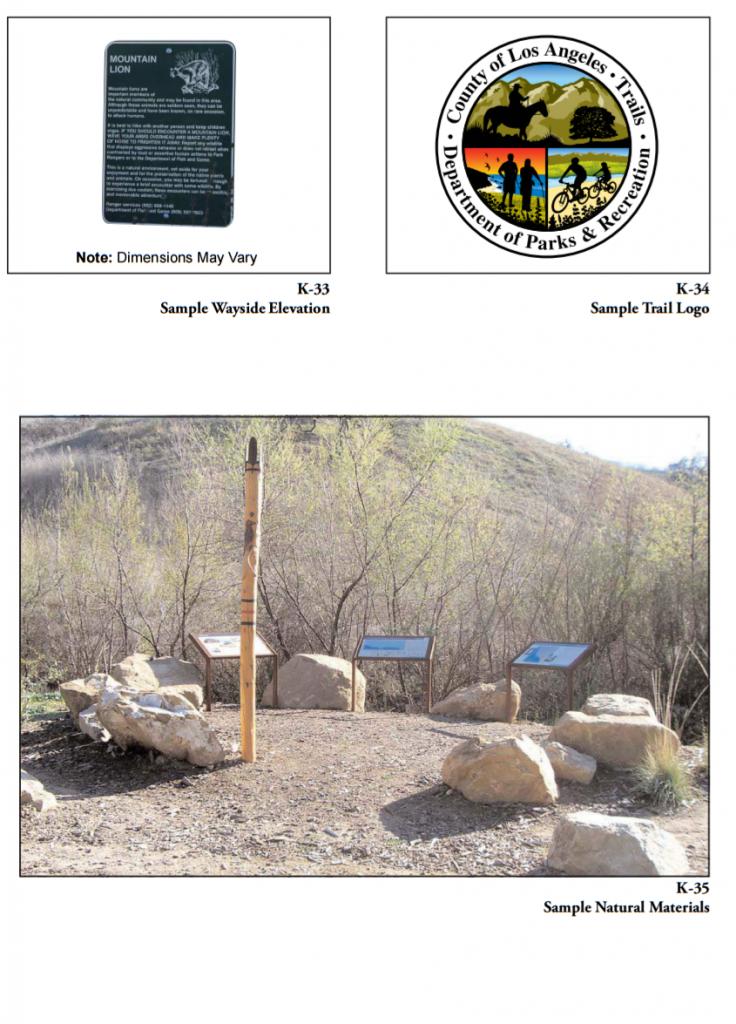
Warning signs provide motorists and trail users with a warming of approaching trail and street intersections. Way-finding sign should be clearly placed in advance of the intersection. Sample Way-finding Sign Text: “Ped Xing” (in some applications, signs may include a County trails logo, directional arrows, usage signs, or the name of the road being crossed) Location and Frequency: Signs should occur at every street and trail intersection. Posting of signs falls under the jurisdiction of the relevant highway regulatory agency such as Caltrans or U.S. Department of Transportation. All highway signs should be coordinated with the appropriate highway agency. Size and Color: The size of signs falls under the jurisdictions of the relevant highway regulatory agency such as Caltrans or U.S. Department of Transportation. All highway signs should be coordinated with the appropriate highway agency. Typically, the Manual on Uniform Traffic Control Devices calls for black lettering on a yellow background. Other Considerations: Warning signs are especially important where visibility is limited. Graphic Example: Figure K-13, Equestrian Crossing, and Figure K-14, Pedestrian Crossing REGULATORY SIGNS Permitted Use (Usage Control) Signs Description and Purpose: Permitted use signs provide trail users with information on permitted and non-permitted uses of the trail. Sample Way-finding Sign Text: “Foot travel only—closed to all other uses” (emphasize permitted use; use a slash for non-permitted uses) Location and Frequency: Post signs at all access points. Size and Color: The color is typically black lettering or image on a white background. Images may include a red circle with a red slash placed diagonally through the image. Graphic Example: Figures K-15, K-16, and K-17, Sample Non-Permitted Use Sign; and Figure K-18 and K-19, Sample Permitted Use Sign Etiquette Signs Description and Purpose: Etiquette signs provide reminders of polite trail behavior for all trail users. Sample Way-finding Sign Text: “Yield to pedestrians,” “Ride and walk on the right,” “Warn others when passing from behind,” “Control speed!,” “Stay alert,” “Use caution around horses,” “Keep dogs on leash,” “No bicycles or horses” Location and Frequency: Post signs before narrow, blind, or contentious sections of trail where trail user conflicts are likely, such as between cyclists and equestrians. Size and Color: The size and color may vary depending on application. Sign should be 2 feet by 1 foot, 2 inches with brown lettering on a white background, bordered in brown. Signs in rural context shall be brown lettering on a white background, bordered in brown with a brown post. Signs in a urbanized neighborhood or suburban context shall be slate gray with black lettering with a black border affixed to a black post. Graphic Example: Figure K-20, Sample Yield Sign “Crossing Private Lands” Signs Description and Purpose: There may be a need for “Crossing Private Lands” signs near the interface between a trail network and adjacent communities. Sample Way-finding Sign Text: “Private land,” “Use of this land is a privilege and not your right,” “STAY ON TRAIL,” “The County depends on the cooperation of many private landowners, please respect the land you travel through,” “Camping, fires, hunting, straying from the trail is prohibited,” “Enforced by County Sheriff,” “Do not block driveways,” “Keep dogs on leash” Location and Frequency: Post signs in and at edges of neighborhoods or private land that the trail crosses. Size and Color: Mount signs on variable-height posts. Signs should be 2 feet by 1 foot, 2 inches with brown lettering on a white background, bordered in brown. Graphic Example: Figures K-9, Stay on Trail Sign, K-10, Existing Stay on Trail Sign, K-21 and K-22, Sample Crossing/ Boundary Sign Boundary Signs Description and Purpose: Boundary signs alert trail users and landowners to the presence of a trail easement. Sample Way-finding Sign Text: “Private land behind this sign,” and on reverse, “Property boundary, Altadena Crest Trail, County of Los Angeles” Location and Frequency: Post signs at all beginnings and endings of easements along trails. Size and Color: Letters should be blue on a white background. Other Considerations: Signs should be two-sided. Graphic Example: Figures K-21 and K-22, Sample Crossing/Boundary Sign Temporary Connector Signs Description and Purpose: Connector signs identify temporary trail segments and encourage their use. Sample Way-finding Sign Text: “Temporary trail, use permitted” Location and Frequency: Post signs at the junctures of existing trails and temporary trails. Size and Color: Letters should be white on a brown background. Other Considerations: Connector signs should be used in connection with Direction Change/Juncture Indicator signs to show change in direction. Graphic Example: Figures K-21 and K-22, Sample Crossing/Boundary Sign INFORMATIONAL SIGNS Entrance Signs Description and Purpose: Entrance signs mark the official entrance to a trail or recreational area. Sample Way-finding Sign Text: “Brown Mountain Trail Network—County of Los Angeles Department of Parks and Recreation,” “Lion’s Den Trailhead” (include trail logo) Location and Frequency: Post signs perpendicular to the road and at all primary trailhead locations. Size and Color: The color is typically white lettering on brown background. Signs may be two-sided so that both entering and exiting trail users can read it. Other Considerations: Coordination with relevant highway department authority such as Caltrans may be required. Graphic Example: Figure K-23, Sample Entrance Sign; and Figure K-24, Entrance Sign Elevation; and Figure K-25, Trailhead Information Trailhead Information Kiosk Signs Description and Purpose: Trailhead information kiosk signs should provide general information about the trail, navigational aids, and safety bulletins. Sample Way-finding Sign Text: Trailhead kiosk signs should include trail-specific information. Panel 1 Information: Panel 2 Information: General trail information Description of local flora and fauna Map of trail network Topographical map and trail profile Trail length and elevation gain/loss Technical difficulty and expected conditions Safety information Cautionary notes, such as a buried cable Maintenance and emergency contact information Location and Frequency: Post signs at all primary trailhead locations within 50 feet of where the trail leaves the parking lot. Size and Color: The kiosk should include a roof and two to three information panels, or a roof with one two-sided panel. Graphic Example: Figure K-26, Sample Kiosk, and Figure K-27, Sample Kiosk Elevation Reassurance Markers Description and Purpose: Reassurance markers provide en route reassurance of trail identity and visually mark the trail line in areas where the trail blends seamlessly with the surrounding area. Sample Way-finding Sign Text: “Silver Cloud Trail—4.5 miles, moderate difficulty” (include trail logo and trail directional arrow) Location and Frequency: Post signs at points of confusion or at every 0.25 mile. Signs should alternate from one side of the trail to the other. Signs are usually posted at eye level. Size and Color: The color should be consistent and blend with the natural palette. Graphic Example: Figure K-28, Sample Reassurance/Directional Sign, and Figure K-29, Reassurance/Directional Elevation Direction Change/Juncture Indicators Description and Purpose: Direction change/juncture indicators alert trail users to a change in direction or juncture with another trail, and may include destinations and distances, features, regulations, warnings, and closures. Sample Way-finding Sign Text: “Cascade Trail closed,” “7.9 miles to First Water Trail Junction” Location and Frequency: Post signs at ambiguous trail turns and at all junctures with other trails. Orient signs to face users approaching from all likely directions. Signs should be used sparingly and posted within sight of a reassurance marker. Size and Color: Signs are typically 4-foot-high wooden posts with trail information in relief along the sides. Sign information should be painted on the post in color. Alternatively, aluminum blazes can be nailed into the post. Other Considerations: Signposts should be placed in areas without erosion issues. Graphic Example: Figure K-28, Sample Reassurance/Directional Sign, and Figure K-29, Reassurance/Directional Elevation Interpretive Signs Description and Purpose: Interpretive signs may display the entire trail network and identify major trail names and important interpretive features such as mountain peaks, streams, plant communities, or historic points of interest. Sample Way-finding Sign Text: ”Birds of the San Gabriel Mountains” Location and Frequency: Post signs at major trailheads and destination features. Size and Color: Letters should be 1.25 inches high and blue, on natural 4-inch-thick wood boards. Other Considerations: An interpretive sign is expensive and can be included as part of the trailhead kiosk to save money on installation and maintenance. Graphic Example: Figure K-30, Sample Interpretive Sign, and Figure K-31, Sample Interpretive Sign Elevation Wayside Exhibits Description and Purpose: Wayside exhibits explain interesting land features, plant and animal communities, historic events, and points of interest. Sample Way-finding Sign Text: “Geological history of Vasquez Rocks” (Text can be several paragraphs in length and should be written in layman’s terminology. Graphics should be integrated with textual explanations.) Location and Frequency: Reserve wayside exhibits for major features located in high-traffic areas. Size and Color: Wayside exhibits should feature native materials. For example, river stones should be used as a base building material if the wayside exhibit is located adjacent to a river. Other Considerations: Wayside exhibits are the most complex and expensive type of way-finding sign. Graphic Example: Figure K-32, Sample Wayside Sign, and Figure K-33, Sample Wayside Elevation. Destination Signs Description and Purpose: These signs show directions and distances to various destinations accessed by the trail network. Sample Way-finding Sign Text: “Horsetail Falls—0.2 miles ahead” (include a directional arrow to the destination) Location and Frequency: Post destination signs at trailheads, major junctions, and spur trails (to water). Size and Color: Letters should be blue and on natural wood boards. Other Considerations: Destination signs direct users to underutilized trail segments by tempting them with the possibility of seeing something special. Graphic Example: Figure K-28, Sample Reassurance/Directional Sign, and Figure K-29, Reassurance/Directional Elevation Adopter Signs Description and Purpose: Adopter signs acknowledge the volunteers who are responsible for trail maintenance along a designated section of the trail. Sample Way-finding Sign Text: “This section of the trail has been adopted by the International Mountain Bicycling Association” Location and Frequency: Post adopter signs on road crossing signs or at beginning of designated clean-up areas. Size and Color: Letters should be blue on a white background. Other Considerations: This is not intended to be an advertisement for the volunteer; adopter signs should be discreet, not a glaring promotion. Graphic Example: Figures K-21 and K-22, Sample Crossing/Boundary Sign TRAIL NETWORK GRAPHICS Confirmation/Identification Signs (Trail Logos) Description and Purpose: Trail logos are graphic symbols that are used throughout the trail network to create consistency, identify the trail network, and orient trail users. Logos can also be standalone badges or blazes that are affixed to a post or a tree. Sample Way-finding Sign Text: “Altadena Crest Trail—County of Los Angeles” Location and Frequency: Include trail logos on all major signs throughout the trail network. Blazes are usually posted at eye level. Size and Color: Trail logos should be small (3 to 6 inches) and colorful. Graphic Example: Figure K-34, Sample Trail Logo You-Are-Here Indicators Description and Purpose: You-are-here indicators are optional markers that are included on interpretive signs or information kiosks to correlate the present physical location of a particular kiosk on a general trail map. Sample Way-finding Sign Text: “You are here” (include an arrow indicating the location of the sign) Location and Frequency: Symbolize you-are-here indicators, and include the symbol on the map legend. Size and Color: The text should be larger than other map text, but should not dominate or distract from the map graphic. SIGN CONSTRUCTION DETAILS AND MATERIALS Specifications for each sign type in terms of materials, background color, font color, and font size is included in Table K-1, Sign Construction Details and Materials. The choice of materials for signs and structures, as well as their structural engineering, should reflect materials indigenous to the immediate area. For example, use river rocks in lowland areas where there are water corridors and use horizontal ledge stones in higher, dryer elevations where that stone is more common (Figure K-35, Sample Natural Materials).


You can read the whole LA County Trails Manual Here: https://trails.lacounty.gov/Files/Documents/121/LA%20County%20Trails%20Manual%20%28Revised%2006-20-13%29%20RS%202016.pdf
©CountyofLosAngeles2013.


Leave A Comment